02 October 2014

Natural Disasters

I'm rather beginning to think the Japanese wish me well but would rather I confine my travels to other ports o' call.

The last time I set the date three years ahead of time to go to Japan, this happened:


and then this:


and of course shortly thereafter, this:


  Shortly after I returned from Japan in 2011 I started planning for this year's return trip. I'm leaving for Japan in the very, very, very early morning.  Shortly after I arrive, I should encounter this.


I tried to get a little footage showing what a category 4 typhoon looks like on the ground but apparently not that many people, once they're actually inside one, determine that going outside for a while to get footage is their best course of action.  So, here's just a photo:


I have to say I found this a bit surprising in view of the fact that people seem perfectly willing to stick their children's heads in the mouths of grizzly bear for a photo to amuse and one-up the neighbors with, or, you know, insert your stupidest photo-taking   I found this one,

but like the child/bear thing this involves someone else's being in danger rather than the photographer.  So maybe, I don't know, there's something about category 4 typhoons that instill a certain amount of reasonableness in people.  Maybe, you know, people who live in the world of typhoons are less likely to be stupid than people who live in the world of hurricanes.


I'm not sure the evidence bears this out however:


Whatever the truth of the matter, however, I will be flying in to Kyoto from the northeast just as typhoon Phanfone (sorry, if you're trying to pronounce that you're on your own) arrives from the southwest.  I've been in hurricanes before, but in all cases I've been in the mountains in temperate climates, usually hours from the sea, which I understand not to be the friendliest environment for tropical storms.

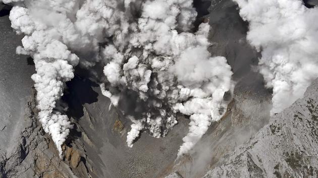
And, who knows, maybe a class 4 typhoon could in a small way settle down the output of Ontakesan, the volcano that just blew in Japan.  In any event I wish you whatever kind of weather you prefer; I'm guess at least that doesn't include volcanoes.  


Whatever your preferences, if you know me, or if you've read much of my little blog, you know that I love rain. Swimming while walking in my street clothes, however, may be another matter.  Also, whether or when I can next blog may be problematic.  Anyway,  じゃまたね、see you soon I hope.


08 January 2014

Date and Time, and a Sense of Place

There's a date and time and probable places for the 2014 trip.  Huzzah.

Departing 3 October 2014.  Staying I hope in Fukuoka, Kanazawa and Nara.  No itinerary yet but I think I know where I'm staying.  

I also wanted to be serious just for a second or two.  I'd like to introduce a friend of mine, the map of Japan superimposed on a map of the eastern U.S.  I don't necessarily like making it so large that it dwarfs the rest of my blog, but I want you to be able to see it, so I don't think I have a lot of choice.

It's really bigger than a lot of people think.


This image has fidelity not only of size but also of latitude, meaning that cities and towns shown on the maps have the same relative latitude, or distance north of the equator.  So for example you'll notice that my current favorite city, Kyoto, has a latitude very close to that of Charlotte and, incidentally, to Henderson County, NC, my home.

Part of the reason I'm showing this map is that there were a number of people who were concerned about my safety when I went to Japan in 2011 a little less than three months after the Fukushima nuclear plant incident.  I kind of wish I'd had this handy map to show those people then.  The plant is just above the top of the "N" in the word "HONSHU," designating the largest of Japan's component islands.  So that would put the nuclear plant, on this map, about 150-200 miles east southeast of Washington DC, well off the east coast of Virginia. 

Kyoto in this case would be in the eastern suburbs of Charlotte NC.  Anyone who drives this area would realize that if this were all land it would take 7 hours of hard driving time on a clear interstate highway (including, I'd suggest, clear of pesky Highway Patrol vehicles with radar guns) to get from one to the other.  When you consider that radiation effects diminish more or less with the cube of the distance between the two spots, you realize that the plant's problems really didn't affect people in Kyoto.  It did however give me clear sailing from long lines of foreign tourists, who didn't realize how small the radiation effects would be in Kyoto.

This also gives you an idea of how varied the climate is in various parts of Japan, when you consider that even the parts of Japan shown on this map stretch from Florida to Canada, and the map doesn't even show Okinawa, the largest of the Ryuku islands that would on this map be well down into the Gulf of Mexico, maybe three hundred miles off the coast of Fort Myers Florida, perhaps about the halfway point on a line between New Orleans and Havana, Cuba.

If you're interested in where I'll be, Fukuoka is the southwesternmost city shown on the map of Japan.  Nara is just south of Kyoto, show on the map in southwestern Honshu (that big island), and Kanazawa, not shown here, is at the base of the western side of the large peninsula that looks a little like Denmark jutting up from the western coast of Honshu.  If you think Japan looks like a dragon, and some people do, this peninsula would be sticking up from the lower back. That's the one.

So, Japanese geography.  My trip in October.  Already gearing up for it.